

what we do

HARDWARE
SOFTWARE
Satellite Data Intelligence
AI-Powered Data
to Action
Search, analyze, and operationalize satellite imagery through intelligent platforms.
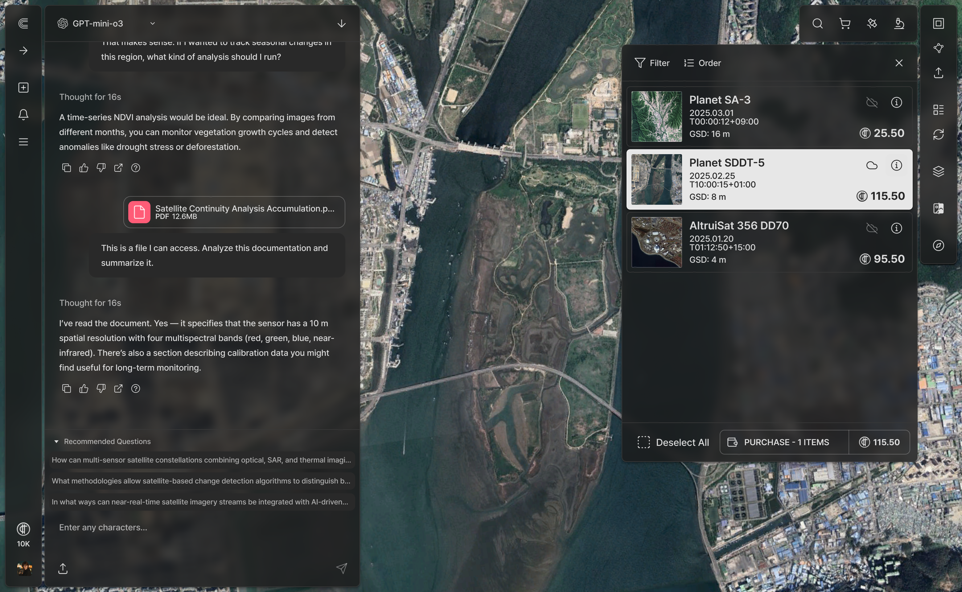
ai agent
SatCHAT
SatCHAT is an AI-powered geospatial intelligence platform that lets users search and analyze satellite imagery using natural language. It simplifies complex remote sensing tasks by turning satellite data into actionable insights.
Powered by SatCHAT
Domain-Specific Intelligence Solutions Built on a Single AI Platform
Ocean Monitoring
Blue Carbon Monitoring
SatCHAT enables high-precision blue carbon monitoring through advanced satellite image analysis. With proprietary sub-pixel detection, it identifies floating algae even in complex marine environments.
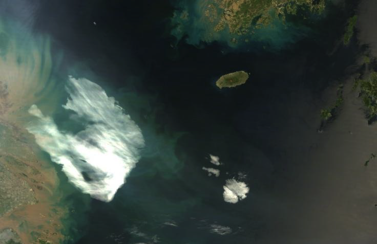
Natural Color Synthetic Image (RGB)
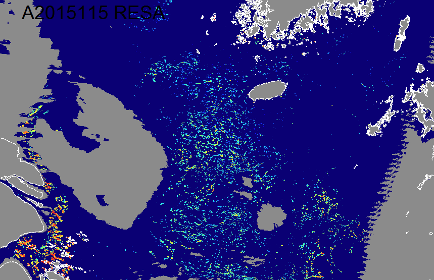
TelePIX’s Algae detection
Urban Monitoring
Terrestrial Monitoring
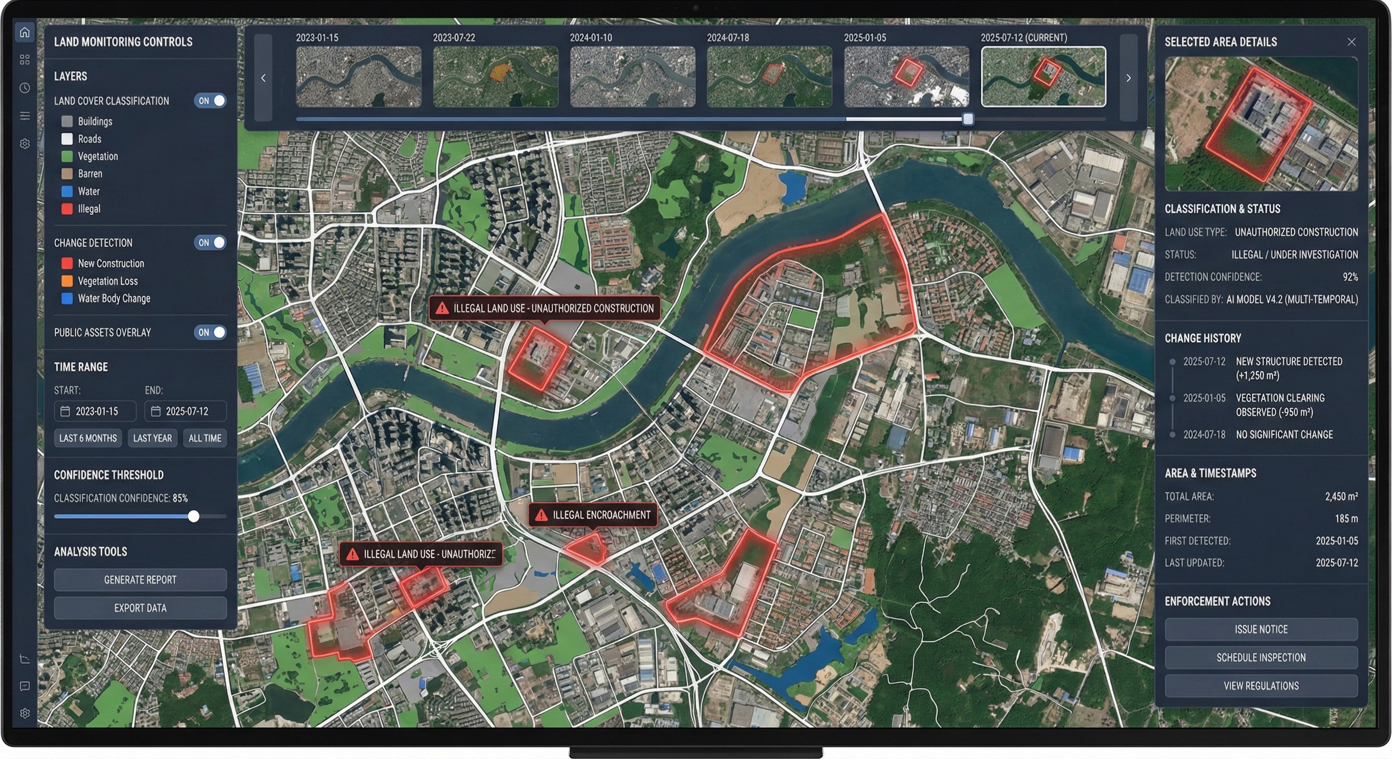
AI-powered terrestrial monitoring built on satellite imagery and the SatCHAT platform. It enables land cover classification, change detection, and data-driven support for land use enforcement.
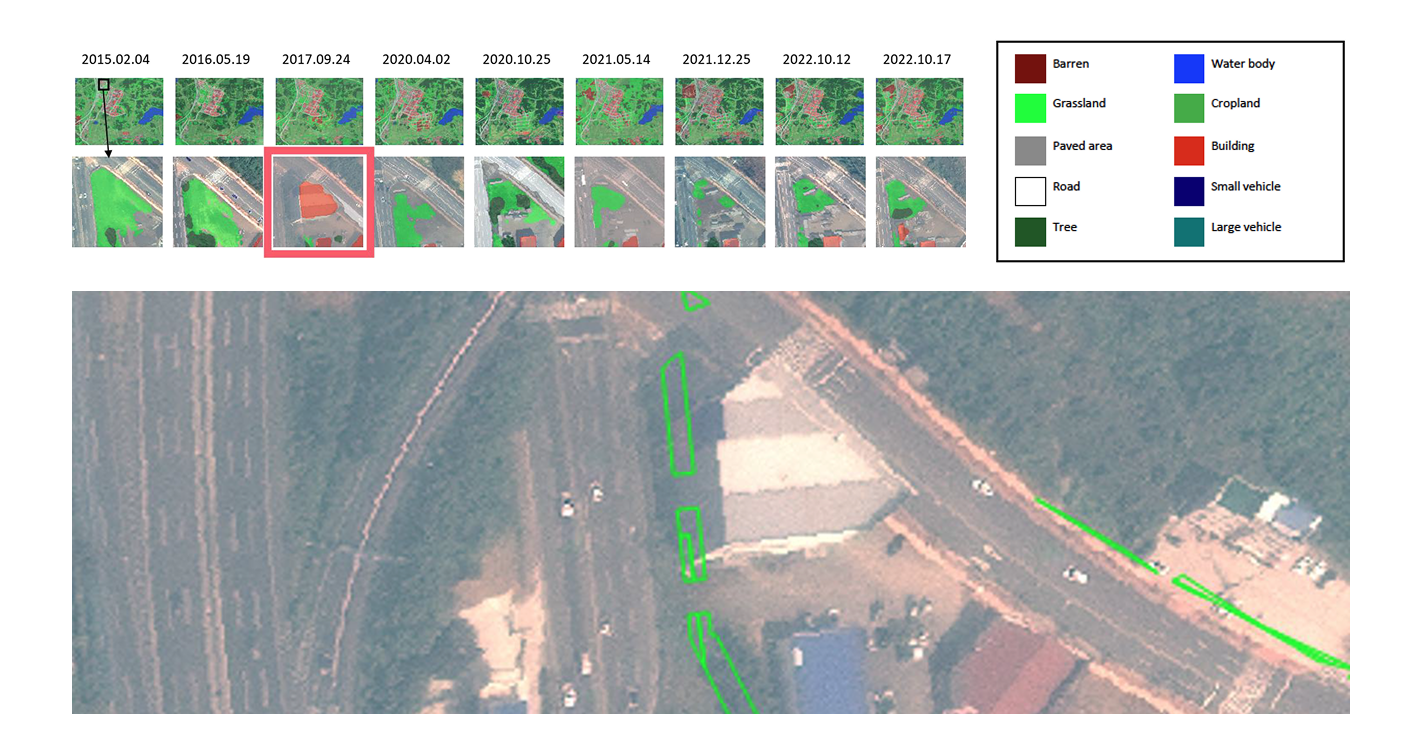
Natural Color Synthetic Image (RGB)
Natural Color Synthetic Image (RGB)
Material Flows
Commodity Monitoring
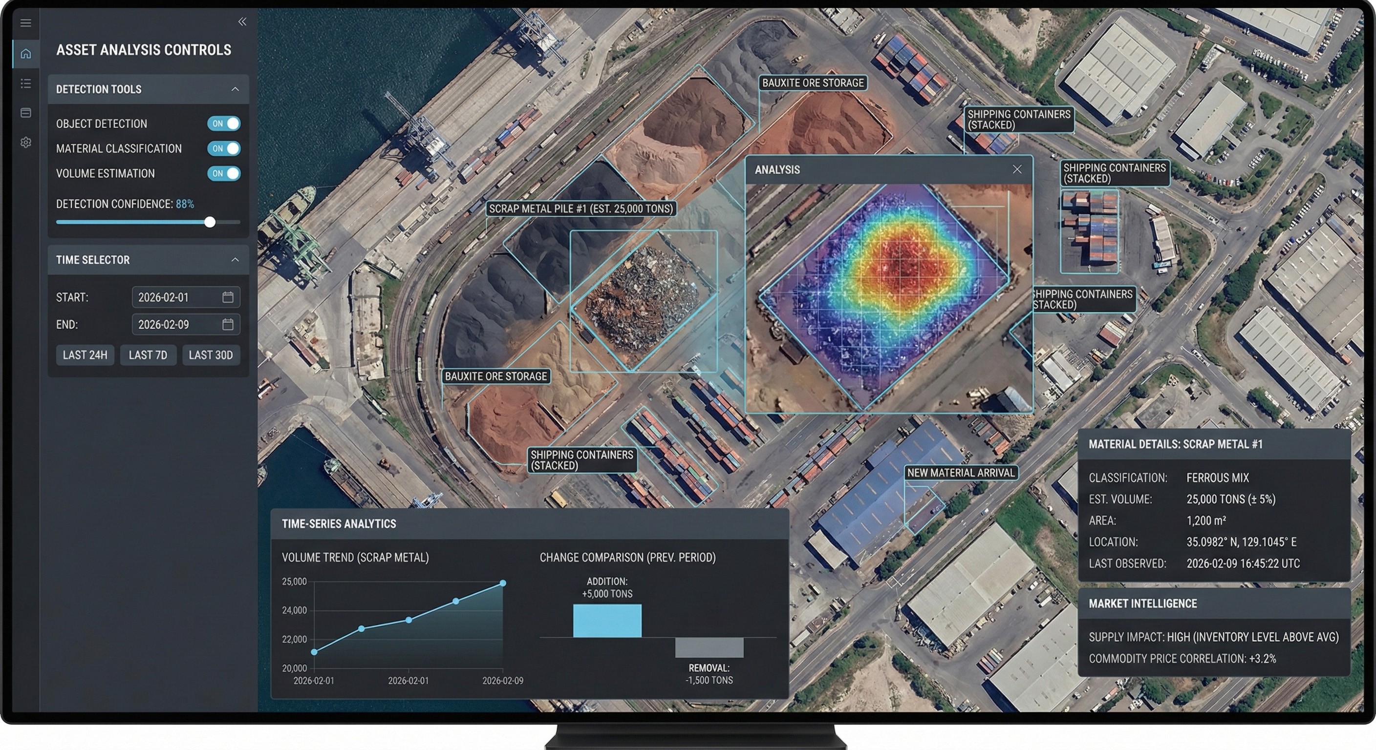
SatCHAT enables commodity monitoring through advanced satellite image analysis. It estimates volumes of raw materials such as scrap metal, grains, and crude oil, delivering market-ready insights for data-driven decisions.
Maritime Intelligence
Vessel Detection
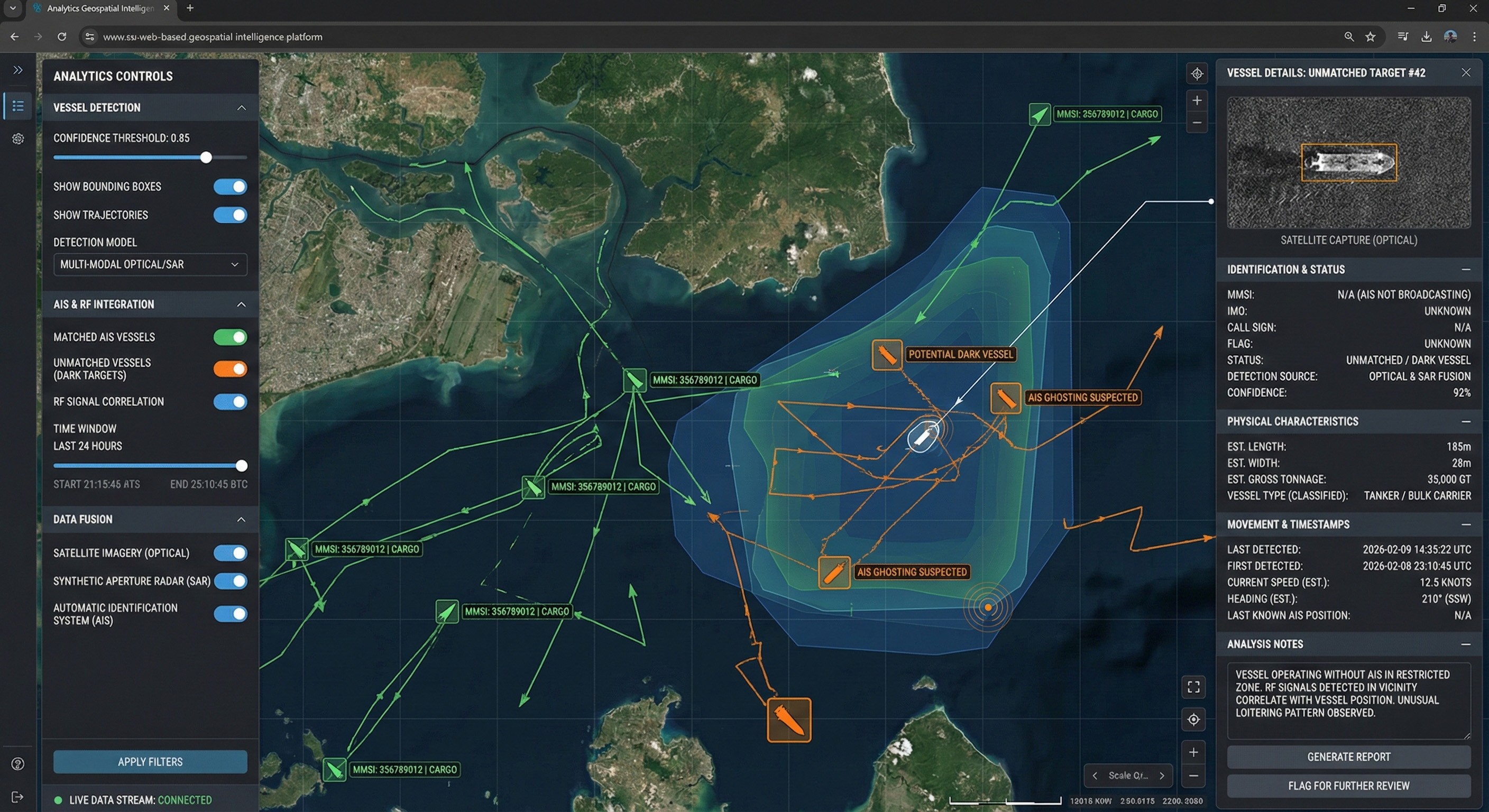
SatCHAT enables AI-powered vessel detection using optical and SAR satellite imagery. By cross-referencing AIS and RF signals, it supports maritime regulation enforcement and coastal security operations.
Need more information?
Get in touch — our team will get back to you shortly.
contact us


18F, 2, Gukjegeumyung-ro 8-gil,
Yeongdeungpo-gu, Seoul, South Korea
서울특별시 영등포구 국제금융로8길 2, 18층
©2026 TELEPIX. All rights reserved.Unauthorized use or reproduction is prohibited.
©2026 TELEPIX.
모든 권리는 텔레픽스 주식회사에 있으며,
무단 전재 및 재배포, 복제를 금지합니다.


what we do

HARDWARE
SOFTWARE
Satellite Data Intelligence
AI-Powered Data to Action
Search, analyze, and operationalize satellite imagery
through intelligent platforms.
ai agent
SatCHAT
SatCHAT is an AI-powered geospatial intelligence platform that lets users search and analyze satellite imagery using natural language. It simplifies complex remote sensing tasks by turning satellite data into actionable insights.
Powered by SatCHAT
Domain-Specific Intelligence Solutions Built on a Single AI Platform
Ocean Monitoring
Blue Carbon Monitoring
SatCHAT enables high-precision blue carbon monitoring through advanced satellite image analysis. With proprietary sub-pixel detection, it identifies floating algae even in complex marine environments.
Natural Color Synthetic Image (RGB)
TelePIX’s Algae detection
Urban Monitoring
Terrestrial Monitoring
AI-powered terrestrial monitoring built on satellite imagery and the SatCHAT platform. It enables land cover classification, change detection, and data-driven support for land use enforcement.
Natural Color Synthetic Image (RGB)
Natural Color Synthetic Image (RGB)
Material Flows
Commodity Monitoring
SatCHAT enables commodity monitoring through advanced satellite image analysis. It estimates volumes of raw materials such as scrap metal, grains, and crude oil, delivering market-ready insights for data-driven decisions.
Maritime Intelligence
Vessel Detection
SatCHAT enables AI-powered vessel detection using optical and SAR satellite imagery. By cross-referencing AIS and RF signals, it supports maritime regulation enforcement and coastal security operations.
Need more information?
Get in touch — our team will get back to you shortly.
contact us


18F, 2, Gukjegeumyung-ro 8-gil, Yeongdeungpo-gu, Seoul, South Korea
서울특별시 영등포구 국제금융로8길 2, 18층 (여의도동, 농협재단빌딩)
©2026 TELEPIX. All rights reserved. Unauthorized use or reproduction is prohibited.
©2026 TELEPIX. 모든 권리는 텔레픽스 주식회사에 있으며, 무단 전재 및 재배포, 복제를 금지합니다.

what we do

HARDWARE
SOFTWARE
Satellite Data Intelligence
AI-Powered Data to Action
Search, analyze, and operationalize satellite imagery
through intelligent platforms.
ai agent
SatCHAT
SatCHAT is an AI-powered geospatial intelligence platform that lets users search and analyze satellite imagery using natural language. It simplifies complex remote sensing tasks by turning satellite data into actionable insights.
Powered by SatCHAT
Domain-Specific Intelligence Solutions Built on a Single AI Platform
Ocean Monitoring
Blue Carbon Monitoring
SatCHAT enables high-precision blue carbon monitoring through advanced satellite image analysis. With proprietary sub-pixel detection, it identifies floating algae even in complex marine environments.
Natural Color Synthetic Image (RGB)
TelePIX’s Algae detection
Urban Monitoring
Terrestrial Monitoring
AI-powered terrestrial monitoring built on satellite imagery and the SatCHAT platform. It enables land cover classification, change detection, and data-driven support for land use enforcement.
Natural Color Synthetic Image (RGB)
Natural Color Synthetic Image (RGB)
Material Flows
Commodity Monitoring
SatCHAT enables commodity monitoring through advanced satellite image analysis. It estimates volumes of raw materials such as scrap metal, grains, and crude oil, delivering market-ready insights for data-driven decisions.
Maritime Intelligence
Vessel Detection
SatCHAT enables AI-powered vessel detection using optical and SAR satellite imagery. By cross-referencing AIS and RF signals, it supports maritime regulation enforcement and coastal security operations.
Need more information?
Get in touch — our team will get back to you shortly.
contact us

18F, 2, Gukjegeumyung-ro 8-gil, Yeongdeungpo-gu, Seoul, South Korea
서울특별시 영등포구 국제금융로8길 2, 18층 (여의도동, 농협재단빌딩)
©2026 TELEPIX. All rights reserved. Unauthorized use or reproduction is prohibited.
©2026 TELEPIX. 모든 권리는 텔레픽스 주식회사에 있으며, 무단 전재 및 재배포, 복제를 금지합니다.